

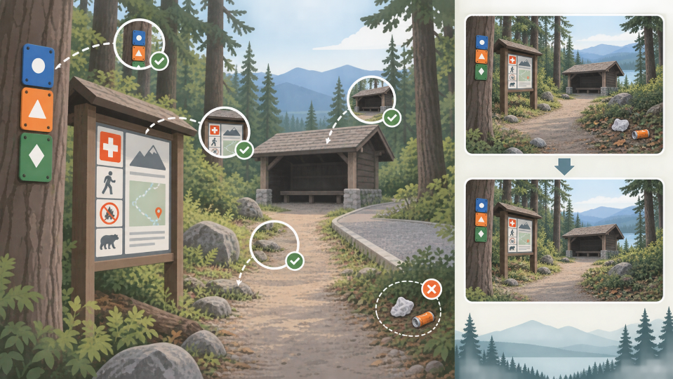
A cleaner trail-shelter photograph can become a worse visitor guide. Removing litter from the foreground may also erase a faded route marker, the edge of an accessible path or an emergency notice fixed to the wall. The image looks calmer, but a walker has lost information needed to recognize the place.
Use an AI Photo Editor only after deciding which details are scenery and which are navigation. Outdoor photographs often carry both roles at once. The path, signs and shelter condition are not background decoration when somebody may plan a visit from the image.
PicEditor AI can produce a cleanup candidate from an uploaded photograph and a written request. Evaluate the AI Photo Editor output against the route landmarks, including any small sign whose purpose is unclear. A disposable cup and a trail marker require different decisions.
Table of Contents
Separate Visual Clutter From Navigation Evidence
Begin by describing what the image is supposed to help a visitor do: find the shelter, recognize a junction, understand the approach or judge current access. A detail is removable only if it does not support that task and does not document the present condition.
Classify Objects By Their Consequence For Visitors
A snack wrapper on a bench may be temporary clutter. A colored paint blaze on the same bench may identify the route. A fallen branch may look untidy but show that the path is partly blocked. Put each visible object into one of three groups: navigation, current condition or disposable distraction.
Do not classify from appearance alone. A small metal plate may carry an emergency location code. A row of stones may mark a drainage edge. Consult the site manager, map or trail guide when an object’s function is unclear.
Preserve Evidence Of Access. Steps, gradients, gate widths, surface changes and handrails help visitors judge whether the route suits them. Removing a rough patch or narrowing a visible slope can make an approach appear easier. If the image is promotional rather than a current access record, pair it with accurate site information.
Map The Landmarks A Visitor Must Recognize
Trace a visitor’s path through the frame from foreground to shelter. Mark the trail edge, junction, route blaze, notice board, entrance and any emergency identifier. This visitor-path map becomes the fixed layer against which every candidate is checked.
|
Landmark |
Why it matters |
Editing rule |
|
Route marker |
Confirms direction |
Preserve color and position |
|
Notice board |
May carry live guidance |
Do not invent readable text |
|
Path edge |
Shows approach |
Keep width and surface |
|
Shelter entrance |
Supports recognition |
Keep geometry |
|
Temporary litter |
No navigation role |
Candidate for removal |
Keep Exact Sign Text Outside Generated Repair
If a sign is unreadable, do not ask the model to reconstruct its wording. Photograph it separately or obtain the current text from the responsible authority. Generated lettering can look plausible while changing a direction, distance or emergency number.
PicEditor AI can make the wider scene easier to view, but exact instructions belong in a verified caption, map or unaltered sign close-up. Link the visual guide to current official route information where practical.
Make One Bounded Cleanup At A Time
Crop a working copy around one distraction and specify the change precisely. Ask to remove the cup beside the bench while keeping the paint blaze, wood grain, path boundary and shadows fixed. A broad request to “make the shelter pristine” risks redesigning the place.
Compare Geometry Before Color. First overlay the candidate on the source and inspect edges. Has the path widened? Did the entrance move? Is a handrail continuous? Geometry changes can affect interpretation more than a shift in color. Only after those checks should the reviewer consider tone or visual balance.
Evaluate the photo edit at the size used on the guide page. A route blaze visible at full resolution may vanish in a thumbnail after nearby contrast changes. That photo edit needs revision if a walker could no longer use the marker to recognize the approach.
Do Not Remove Current Hazards For Appearance
Mud, storm damage, snow or a blocked entrance may date quickly, but they are not ordinary clutter when the post describes present conditions. Either publish the current scene with a date, take a new photograph after conditions change or label an older promotional image clearly.
Walk The Edited Image From Trail To Shelter
Review the candidate in the order a first-time visitor would encounter the site. Can they locate the path, recognize the junction, confirm the correct marker and identify the entrance? Each step should be supported by a visible landmark or accompanying verified instruction.
Ask A New Viewer To Point Not Explain. Give the source map and edited photograph to someone unfamiliar with the location. Ask them to point to the route marker, approach and shelter entrance. Pointing reveals whether the detail is actually visible; a verbal answer may rely on assumptions from the prompt.
Then show the unedited image. If the viewer identifies a useful landmark that disappeared from the candidate, restore the source or abandon the cleanup. Do not compensate with an arrow placed over an inaccurate scene when the original landmark could simply remain.
Check The Photograph’s Season And Camera Viewpoint
Leaves, snow and vegetation can change visibility. A photograph from one season may not prepare visitors for another. Record the month and camera position. If several approaches exist, do not let one attractive view imply that it is the only or universally accessible route.
Compare the edited scene with the current official map at the level the photograph can support. The image may confirm that a junction and shelter exist in the same view, but it cannot establish walking time or route difficulty on its own. Keep distances, grades and closures in verified text that can be updated without rebuilding the picture.
For an unfamiliar site, ask the local maintainer to review the candidate. They may recognize a drainage channel, seasonal gate or boundary marker that a remote editor sees as clutter. Their review is not a substitute for the source comparison; it adds site knowledge to the same landmark checklist.
Publish The Scene With Current Conditions
PicEditor AI fits an outdoor communication workflow when the edit is narrow and every navigation landmark is checked against the source. It should not turn a documentary site image into an idealized landscape that visitors cannot match on arrival.
Caption the photograph with its date, viewpoint and the purpose of any alteration. Link to current closures, access notes and emergency guidance maintained by the responsible organization. The image can support those sources but should not replace them.
If the post remains online for months, assign a review date. Conditions may change even when the editing remains accurate to the old source. An archived image can stay useful when its date is clear; an undated image may be mistaken for a live report long after vegetation, signs or access have changed.
Archive the original, visitor-path map, prompt, accepted derivative and review notes. A useful shelter photograph does more than look inviting. It keeps the small markers, edges and signs that let a person move from trail to refuge without guessing what the cleanup removed.